First published on
07/23/2017 - 19:00
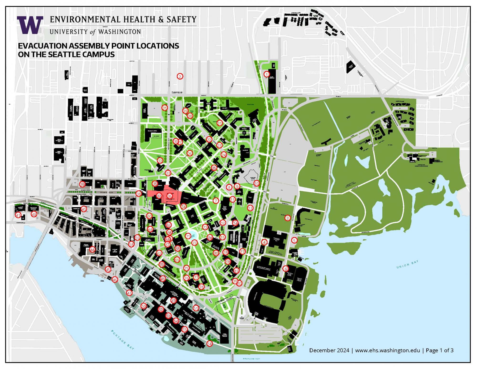
EVACUATION ASSEMBY POINT LOCATIONS ON THE SEATTLE CAMPUS
Location descriptions
- Parking Lot N26-W
- Parking Lot N26-E
- IMA Sports Field
- North of Graves Building
- Parking Lot E8
- Parking Lot E9 West of Nordstrom Tennis Center
- HUB Yard/Grieg garden
- Parking Lot N22
- Wakiakum Walkway
- Parking Lot N24, North of Fluke Hall
- HUB Loading Dock
- Parking Lot C17, East Side of Building
- Parking Lot N24, South of Fluke Hall
- Lowe Hall Loading Dock
- Lawn-Stevens Way at Benton Lane
- Snohomish Lane Plaza at Stevens Way
- Mason and Jefferson Roads
- Mueller Patio Roof Area
- Parking Lot C12 East of Wilcox hall
- Parking Lot C12 South of Wilson Annex
- Denny Field
- Lawn Area West of McKenzie Hall
- Lewis Front Lawn (West Side of Building)
- Lawn North of Music Building Along Stevens Way
- QUAD Lawn
- Denny Yard
- Parking Lot N3
- Archery Range East of Parking Lot N5
- Parking Lot N5
- Parking Lot N2
- Parking Lot N1
- Lawn Area North and West of Parrington Hall
- Flag Pole Plaza
- Grant Lane South of Suzallo Library
- Gravel and Lawn Area West Of Odegaard Library
- Red Square
- By George Washington Statue
- Campus Parkway
- Parking Lot W41
- Parking Lot W10
- Parking Lot W44
- Parking Lot W40
- Parking Lot W40
- Parking Lot W35
- Parking Lot W34
- South of Boat Street
- Open Area N. of Oceanography Tec Svcs Mach Shop
- Courtyard Between T Wing and HS Annex 4
- K Wing Courtyard
- Parking Lot S12
- C Wing Courtyard
- Parking Lot S1, North End
- Parking Lot S1, Center Section
- Parking Lot S1, South End
- Parking Lot S9
- NE Columbia Road
- CHDD School Yard
- South of Purchasing and Accounting
- Parking Lot W14
- Parking Lot C8
- West of Guthrie Hall
- Plaza between Physics & Astronomy Tower/Bldg/Aud
- Between Johnson Hall and Molecular Sciences
- North of Chemistry Library
- Parking Lot C7
- Open Lawn West of Chemistry Library
- Parking Lot C7
- Between Benson Hall and Okanogan Lane
- By Medicinal Herb garden
- North End of Hitchcok Overpass
- NW Corner of Drumheller Fountain plaza
- NE Corner of Drumheller Fountain plaza
- SW Corner of Drumheller Fountain plaza
- SE Corner of Drumheller Fountain plaza
- South Bus Stop at Stevens Way and Garfield Lane
- North End of Health Sciences Skybridge
- Bloedel Courtyard
- Parking Lot C10
- South 1/2 of Rainier Vista
- North 1/2 of Rainier Vista
Download the map.
Visit the Building Evacuations and Fire Drills page for more information.
Resource id:
205
File Upload
Category:
